


The South Australian Department for Energy and Mining (DEM) has produced a geological map in an Aboriginal language for the first time in a bid to bridge the gap with the Indigenous community.
The recently released palaeovalley map of the Anangu Pitjantjatjara Yankunytjatjara (APY) Lands in the northwest of South Australia has been translated into Pitjantjatjara by the Iwiri Aboriginal Corporation.
Carmen Krapf, a geologist who worked on the project, said the intention for the translation is to encourage two-way communication between the local community and the DEM. Originally from Germany, it was Krapf’s passion for language that led to the map’s translation.
“When I started working at the APY Lands I took a language course at the University of South Australia to be prepared,” Krapf shared.
“I felt passionate about publishing it in the language of the people in the community if they had any need to follow up or ask questions.”
She noted that the DEM supported this passion and shared the same values of connecting to the First Nations people in remote communities.
“If you work in a place where the people don’t speak the language, you owe it to them to publish your findings in their language,” Krapf said.
“Researchers come and they use the community and don’t give anything back to that community.”
“Indigenous cultures are about learning and sharing, and science is always forgetting to share.”
The original paleovalley map is a product of the Goyder Institute for Water Research’s Facilitating Long-term Outback Water Solutions (G-FLOWS) project Phase 3, a partnership between the Department for Environment and Water, the CSIRO, Flinders University, DEM and the Geological Survey.
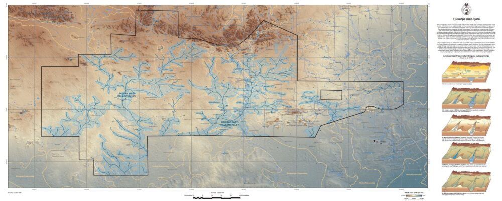
According to DEM, the map shows the interpreted distribution of palaeovalleys that are hidden beneath the surface of the modern-day sandplains, dunefields and creeks.
It includes for the first time information about the location of the deepest part of the palaeovalley via thalweg mapping.
The map was compiled using airborne electromagnetic (AEM) data and newly acquired drilling data from two selected hydrogeological control sites in the vicinity of the community of Kaltjiti (Fregon).
Krapf detailed that traditionally when people were exploring water, they would look for existing water resources, but this map shows where the ancient river systems are, so they are able to take advantage of a new water source.
“Ultimately the map is used as guidance for the community to find new water resources,” she said.
Through this project, the discovery of new potable groundwater resources near Kaltijiti has the potential to create new opportunities for the community.
“They are running out of water and the water they do have is salty. We are trying to look for sustainable resources,” Krapf said.
“APY Lands are keen to bring more agriculture in and you need bores and other water sources to do that effectively.”
“This map can be provided to plan your drilling program around,” she added.
Printed copies of the map will be available via the Umuwa APY Board’s office.
Both the English and Pitjantjatjara versions of the map can be downloaded via the South Australian Resources Information Gateway (SARIG).